Historic Sites | Discover Boyne Valley

Historic Sites

Dowth Hall

Photo credit - Eamonn Gosling Masterpiece Aerial Photography 

Please note: Dowth Hall is not open to the public at this. More details on the Boyne Valley National Park will be announched in due course. 

The Boyne Valley National Park will be the 7th in Ireland and will join Wild Nephin in Mayo, The Wicklow Mountains National Park, The Burren National Park in Clare, Killarney National Park in Kerry, Glenveagh National Park in Donegal and Connemara National Park in Galway. 

Dowth Hall

Dowth,
Slane,

Co. Meath

(not open to the public at present)

53.705419193411686
-6.440000801749931

Castlekeeran monastic site

The early Christian monastery of Castlekeeran is situated in the valley of the River Blackwater. Very little remains of the structure of this 8th century monastic settlement  but with three high crosses, an Ogham stone and a early cross slab grave on the wall of the one remaining part of the church it was worth paying a visit to. 

Castlekeeran,

Kells,

Co. Meath

53.74112691926373
-6.954369644123621

St Ciaran's Holy Well

St. Ciaran's (also seen as St. Kieran's) Holy Well is near both Castlekeeran (and its monastic site) and Carnaross townlands (approximately three miles). The well is of bedrock and is accessible by crossing one of two bridges across a river. The main well is situated beside a large ash rag tree and has two steps descending into its gorge; two others are proximal and follow along the rock streambed.

St. Ciaran's Well

Castlekeeran,

Co. Meath

53.739079222105374
-6.958656401997553

Ardee Castle

Located on the east side of Castle Street, this building ranks as the largest fortified town house to survive in Ireland. The mass of its masonry makes it the most noticeable of the remains of the medieval town of Ardee. Dating from the fifteenth century, this structure is known as ‘Ardee Castle’, ‘St Leger’s Castle’ and ‘Pipard’s Castle’.

53.855124553015806
-6.5387358338797394

Ardmulchan Church

The town land of Ardmulchan hugs one of the most beautiful bends on the River Boyne between Navan and Slane. For the most part the area was retained by Hugh de Lacy until sometime at the end of the 12th century. This was at a time when defense of the Boyne was vital to the establishment of the Norman colony in Meath. A substantial motte was built, along with a church and several chapels rebuilt on pre Norman foundations. The church tower may be as early as 13th or 14th century. The present ruins of the church seem to be 15th century.

Boyne Rd, Navan, Co. Meath

Please be careful pulling out of the laneway onto the main road when exiting, as visibility is restricted.

View location on Google Maps here 

From Navan:

Take the R153 (turning right over the bridge if heading northbound towards Cavan) for Duleek/Ashbourne. Take a slight left at the first junction for the Boyne Rd. Continue on the Boyne Rd for about 3km, you will see signs on the left for Ardmulchan.

From Dublin:

Take the M3 (this road is tolled) headed for Cavan. At junction 8, exit toward R147/Navan (South). Merge onto Navan (South). Turn left onto R147. Turn right onto the R153 for Duleek/Ashbourne. Take a slight left at the first junction for the Boyne Rd. Continue on the Boyne Rd for about 3km, you will see signs on the left for Ardmulchan.

Via M1 Motorway or Drogheda:

From the M1 (this road is tolled) coming from Belfast, take the exit for junction 10, take the N51 exit to Slane/Drogheda North. At the roundabout, take the 3rd exit onto N51 headed for Slane. If coming from Drogheda take the N51 headed towards Slane also. In Slane take a left on the N2 towards Dublin. About 2km outside Slane turn right onto L1600 for Trim/Navan. Continue straight down this road for 6 km until you see the signs for Ardmulchan on the right.

53.6718
-6.62855

Athlumney Castle Navan

Athlumney overlooks a key strategic point, where the Leinster Blackwater drains into the Boyne. The placename derives from the Irish for "Loman's ford", referring to Lommán of Trim. Archaeological digs uncovered an Early Christian souterrain.

The motte at Athlumney (which preceded the existing castle) was built in the years after 1172 when Hugh de Lacy, Lord of Meath granted the title of Baron Skryne to his ally Adam de Feypo; he in turn granted Athlumney to a relative Amauri de Feipo, who built the motte.

Convent Rd, Navan, Co. Meath.

View location on Google Maps here 

Athlumney is situated on the East Bank of the Boyne River and to find it take the M3 from Dublin to Cavan. Exit at junction 7 and follow the signs for Navan. At Navan take a right turn onto Athlumney Rd towards Kentstown This is the R153. Take the first turn right onto Convent Rd which is a narrow road with a one way system, so you will have to exit from it's other end when leaving. You can park near a green area in the Athlumney Castle housing estate just adjacent to the Castle and have a good walk around.

53.65030596301314
-6.675151761576457

Battle of the Boyne Site

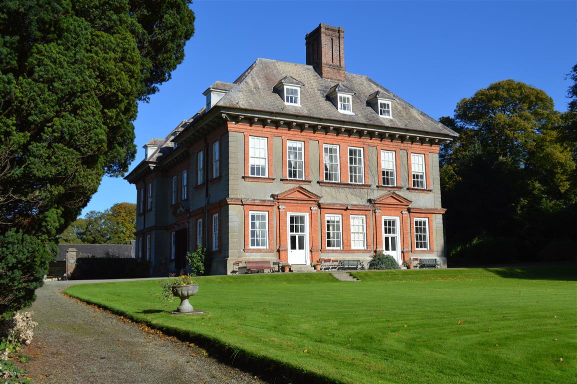
Battle of the Boyne Visitor Centre: Oldbridge House and Gardens

    The Battle of the Boyne (1690) is one of the most significant events in Irish history, part of a wider struggle for power across 17th century Europe.

    +353 (0) 41 9809950
    battleoftheboyne@opw.ie

    Battle of the Boyne Visitor Centre
    Oldbridge House
    Oldbridge
    Drogheda
    Co. Meath
    A92 CY68

    See website for further details.

    View location on Google Maps 

    By car: The Battle of the Boyne Visitor Centre is located on the South bank of the River Boyne, 3km north of Donore Village. The site is sign-posted from Exit 9 off the M1 (Dublin/Belfast), off N2 (Slane/Ashbourne and off N51 (Slane/Drogheda) – the N51 is Not Suitable for Coaches. Coach Parking available in Visitor Centre Car Park.

    Bus Services from Drogheda to the Battle of the Boyne www.buseireann.ie

    Bru na Boinne (Newgrange and Knowth) bus link 188

    TFI Local Link Route 188 connecting Rathcairn, Athboy, Navan, Duleek, Donore, and Drogheda with Brú na Bóinne and the Battle of the Boyne Site.  The route operates 8 times per day, 7 days per week providing improved access to our heritage sites.  Access the Athboy to Drogheda timetable and many more Local Link timetables available at www.locallinklmf.ie/rrs-daily-services.

    Airport

    Distance from Dublin International Airport is 44Km

    Port

    Distance from Dublin Port is 50km

    Distance from Dun Laoghaire Port is 63Km

    Locate Us:

    GPS: 53.722699, -6.412969

    May - September    (Open Daily)   10am - 5.00pm

    October - April     (Open Daily)   9am - 4.00pm


    PLEASE NOTE:  Main Entrance Gate to estate locked at 4pm sharp.  Exit Gate locks at 6pm sharp.  A call-out fee will apply for vehicles still parked in car park after the 6pm deadline. 

    See website and Facebook for up-to-date information on visiting and access.

    http://facebook.com/battleoftheboyne

    Adult                      €5.00

    Senior/Group         €4.00

    Child/Student        €3.00 (Children under 12 are free of charge)

    Family                  €13.00

    No group bookings available until further notice

    Online Booking – BOOK HERE

    If you are unable to book online please telephone 041 980 9950 for assistance.

    53.7235
    -6.42346

    Beaulieu House & Gardens

    Beaulieu House is a 17th Century house and gardens.It is one of the first unfortified houses built in Ireland and designed around an old Plunkett property by Sir Henry Tichbourne, who was granted a Patent to the lands in 1666, by Charles II.

    Situated on the north bank of the river Boyne between Drogheda and the Irish Sea, the estate was originally owned by the ‘St. Oliver' branch of the Plunkett family and was the Army in Ireland and Governor General of Drogheda at the time of the Restoration of Charles II.

    +353 (0)41 9845051
    beaulieu.house.garden@gmail.com

    Beaulieu House, Gardens & Car Museum,Drogheda,Co Louth

    For opening times, please visit http://beaulieuhouse.ie/

    https://www.facebook.com/BeaulieuIreland

    Please see website for bookings and prices

    53.7277
    -6.29525

    Donaghmore Round Tower & Cemetery

    Saint Patrick is said to have first founded a monastery here, giving charge of it to one of his followers, St. Cassanus. The existing ruins, however, do not date back that far. The architectural style of the church indicates it was built in the 15th Century. Most likely, it replaced an older church built in the Romanesque style; a carved Romanesque head is incorporated in the south wall of the bell tower. The round tower predates the church and was built in the 9th or 10th century. It is well-preserved though missing its conical cap.

    Slane Road,Navan

    View location on Google Maps here 

    From Dublin take the M3 motor way(this road is tolled), leaving at Exit 8 or N3 to Navan, on continue through Navan and take a right just beyond the turn for Kentstown, you will see a sign N 51 Kingscourt /Drogheda, go up Flower Hill and keep right round the roundabout at the Round O public house. The cemetery is about a mile on the left-hand side of the Slane road, you will see a sign with a P (Park) & + Cross, turn left here and a few yards up this road you will see a Round Tower and gate leading to the cemetary.

    Via M1 Motorway or Drogheda: From the M1 (this road is tolled) coming from Belfast, take the exit for junction 10, take the N51 exit to Slane/Drogheda North. At the roundabout, take the 3rd exit onto N51 headed for Slane. If coming from Drogheda take the N51 headed towards Slane also. Continue on the N51 through slane towards Navan after approx 9kms there should be signage for Donaghmore Round Tower & cemetary

    Free

    53.6707
    -6.66245

    Donaghpatrick Church

    Saint Patrick`s Church was built in 1896, designed by J.F. Fuller, an authority on the Hiberno-Romanesque style

    In 1862 the London-trained Fuller had answered an advertisement for a district architect under the Irish Ecclesiastical Commissioners; he was chosen from among 97 candidates: St. Patrick`s is one of his finest creations.

    Donaghpatrick Church and site

    Donaghpatrick,Teltown,Co. Meath

    View location on Google Maps here 

    From Dublin take the M3 motor way (this road is tolled), leaving at Exit 9 At the roundabout, take the 3rd exit onto N51, Go through 2 roundabouts, At the roundabout, take the 1st exit onto Kells Road/R147. Continue to follow R147, (6km) Turn right toward Windtown Road, Turn left onto Windtown Road, Donaghpatrick, Co. Meath

    Via M1 Motorway or Drogheda: From the M1 (this road is tolled) coming from Belfast, take the exit for junction 10, take the N51 exit to Slane/Drogheda North. At the roundabout, take the 3rd exit onto N51 headed for Slane. Coming from Drogheda take the N51 headed towards Slane also. Continue on the N51 through Slane. At the roundabout, take the 3rd exit onto N51, Go through 1 roundabout, (13km) Turn right onto Ratholdren Road, Continue onto Windtown Road for 3km and then you reach Donaghpatrick.

    Free

    53.6964
    -6.76